Randonnée A pied Le Valtin - 20. Les belvédères des trois lacs - Photo

20. Les belvédères des trois lacs

Tous les sentiers balisés d’Europe PRO

© OpenStreetMap contributors
Longueur
Longueur
4,5 km
Altitude max
Altitude max
1299 m
Dénivelé positif
Dénivelé positif
113 m
Km-Effort
Km-Effort  
6,6 km
Altitude min
Altitude min
1062 m
Dénivelé négatif
Dénivelé négatif
273 m
Boucle
Boucle
Non
Balise
Balise
Date de création :
2022-02-15 00:10:56.203
Dernière modification :
2022-03-02 09:37:27.413

(0 Avis)

A pied
A pied
1h29
Difficulté : Facile

Scannez ce code QR pour ouvrir la randonnée dans l'application SityTrail

Application GPS de randonnée GRATUITE

Logo SityTrail SityTrail

IGN / Instituts géographiques

Télécharger SityTrail sur l'App Store Télécharger SityTrail sur Google Play

Logo SityTrail SityTrail World

Le monde est à vous

Télécharger SityTrail sur l'App Store Télécharger SityTrail sur Google Play Télécharger SityTrail sur Huawei AppGallery

À propos

Randonnée A pied de 4,5 km à découvrir à Grand Est, Vosges, Le Valtin. Cette randonnée est proposée par SityTrail - itinéraires balisés pédestres.

Description

30 balades en famille autour de Gérardmer - Schlucht-Hohneck, La Bresse, vallée des Lacs, haute Meurthe de Anne Renac - Éditeur Glénat - Livraison gratuite à 0,01€ dès 35€ d'achat - Librairie Decitre votre prochain livre est là

Site web: https://www.decitre.fr/livres/30-balades-en-famille-autour-de-gerardmer-9782723462952.html

Photos

Localisation

Pays :
France
Région :
Grand Est
Département/Province :
Vosges
Commune :
Le Valtin
Localité :
Unknown
Départ:(UTM)
355919 ; 5330233 (32U) N.

Randonnées à proximité

Randonnée Randonnée équestre Orbey - 2020-06-28 WE Orbey Petit Hohnack Glasborn - Photo
Randonnée équestre
GUIDE
holtzv

Randonnée équestre

Difficile
(1)
Orbey, Grand Est, Haut-Rhin, France
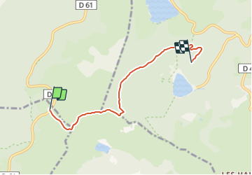
22 km | 31 km-effort
4h 5min
Oui
Randonnée Randonnée équestre Orbey - 2020-06-27 WE Orbey Noir Gazon Vert Forlet - Photo
Randonnée équestre
GUIDE
holtzv

Randonnée équestre

Moyen
(1)
Orbey, Grand Est, Haut-Rhin, France
21 km | 30 km-effort
3h 59min
Oui
Randonnée Marche Stosswihr - Tour du belvedere avec le passage sur les crêtes  - Photo
Marche
ocepee

Marche

Très facile
(2)
Stosswihr, Grand Est, Haut-Rhin, France
8,5 km | 0 m-effort
2h 28min
Oui
Randonnée Autre activité Soultzeren - Totom 4 lacs - Photo
Autre activité
dinozore

Autre activité

Moyen
(1)
Soultzeren, Grand Est, Haut-Rhin, France
15,6 km | 26 km-effort
4h 37min
Oui
Randonnée Marche Hohrod - Circuit historique 1914-18 Hohrodberg - Linge - Photo
Marche
VacheKiri67

Marche

Moyen
(1)
Hohrod, Grand Est, Haut-Rhin, France
14 km | 19,8 km-effort
5h 50min
Oui
Randonnée Marche Orbey - Le Tour du Lac Blanc par le Rocher Hans et le sentier de crête - Photo
Marche
tracegps

Marche

Difficile
(3)
Orbey, Grand Est, Haut-Rhin, France
4,4 km | 7,7 km-effort
2h 30min
Oui
Randonnée Marche Le Bonhomme - Tête des faux . - Photo
Marche
heurtinpatrick

Marche

Moyen
(1)
Le Bonhomme, Grand Est, Haut-Rhin, France
11,9 km | 16,6 km-effort
3h 46min
Oui
Randonnée Marche Soultzeren - Tanet-Gazon du faing par lac vert et retour sommet du Tanet - Photo
Marche
ride-in-Elsass

Marche

Moyen
(1)
Soultzeren, Grand Est, Haut-Rhin, France
10 km | 15,6 km-effort
4h 24min
Oui
Randonnée V.T.T. Orbey - Lac Blanc  - Têtes des Faux - Photo
V.T.T.
tracegps

V.T.T.

Moyen
(1)
Orbey, Grand Est, Haut-Rhin, France
15,3 km | 21 km-effort
1h 0min
Oui


Fermer
Mes abonnements